Circular hiking trail A 1 - fire brigade Homberg

GPX

PDF

12,37 km long
regional hiking trail
During the 12 km long hike we overcome some, partly more demanding ascents with a walking time of around 3 hours.
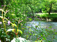
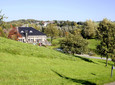
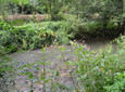
Naturally, we are on the Mettmann loess terraces within the main unit of the Bergisch-Sauerland Unterland. It is a forest-free, flat, undulating, wide terraced area with a thick and fertile loess loam layer. The path leads us from Homberg through the Schwarzbachtal into the Angertal. Through the Homberger Bachtal we reach Homberg again.

Good to know

Arrival & Parking

Parking: Dorfstraße, fire station/cemetery

Public transportation

stop: Dorfstraße, lines 748, 761, 771

Contact person: in

Office for Culture and Tourism Ratingen

author

Office for Culture and Tourism

Düsseldorfer Strasse 26
40822 Mettmann

0049 2104 99-0

info@neanderland.de

Organization

Nearby

tour dates
Start: Dorfstrasse car park at the Homberg fire brigade
Destination: Dorfstrasse car park at the Homberg fire brigade

medium

03:17 p.m

12,37 km

148m

148m

77m

150m

You seem to be using Microsoft's Internet Explorer Web browserto view our website.

For functionality and security reasons, we strongly recommend using an up-to-date web browser such as Firefox, Chrome, Safari, Opera or Edge to use. Internet Explorer does not display all of the content on our website correctly and does not offer all of its functions.